San Diego County on the map of California 2026. Cities, roads, borders and directions in San Diego County of California.
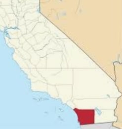
USA / California / San Diego CountySan Diego County is one of the most populous counties in the United States. It is located on the southern edge of California, along the border with Mexico. The county seat is San Diego. The total population of this county exceeds 3.3 million people. This map shows the borders of San Diego County as well as neighboring counties, including major highways and natural objecsts as of 2026. Zoom in or out of the map using the plus/minus panel. Move the center of this map by dragging it. Also check out the satellite map of San Diego County.
The borders of San Diego County over the map of California
Explore some more counties of California:
- Yuba County
- Yolo County
- Tuolumne County
- Tulare County
- Trinity County
- Tehama County
- Sutter County
- Stanislaus County
- Sonoma County
- Solano County
- Siskiyou County
- Sierra County
- Shasta County
- Santa Cruz County
- Santa Barbara County
- San Mateo County
- San Luis Obispo County
- San Benito County
- Plumas County
- Placer County
Full list of California maps
This online map of San Diego County, California is provided by Bing Maps. Please add a bookmark and share the page with your friends!
© 2026 City maps and famous places