Coles County on the map of Illinois 2026. Cities, roads, borders and directions in Coles County of Illinois.
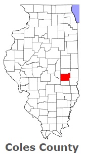
USA / Illinois / Coles CountyColes County is situated in the eastern region of Illinois. This wonderful county was named after Edward Coles (1786-1868), second Governor of Illinois, responsible for the abolition of slavery in Illinois. The area of Coles County is about 508 square miles. The county, organized in 1830, is populated today by 47 thousand residents. Charleston is the county seat of Coles County. This map shows the borders of Coles County as well as neighboring counties, including major highways and natural objecsts as of 2026. Zoom in or out of the map using the plus/minus panel. Move the center of this map by dragging it. Also check out the satellite map of Coles County.
The borders of Coles County over the map of Illinois
Explore some more counties of Illinois:
- Woodford County
- Winnebago County
- Williamson County
- Will County
- Whiteside County
- White County
- Wayne County
- Washington County
- Warren County
- Wabash County
- Vermilion County
- Union County
- Tazewell County
- Stephenson County
- Stark County
- St. Clair County
- Shelby County
- Scott County
- Schuyler County
- Sangamon County
Full list of Illinois maps
This online map of Coles County, Illinois is provided by Bing Maps. Please add a bookmark and share the page with your friends!
© 2026 City maps and famous places