Macoupin County on the map of Illinois 2026. Cities, roads, borders and directions in Macoupin County of Illinois.
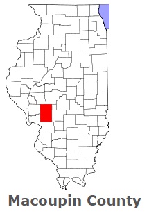
USA / Illinois / Macoupin CountyMacoupin County is found in the western region of Illinois. This awesome county was named after Native American word macoupin, meaning American lotus. The population of Macoupin County exceeds 44 thousand people. The county, formed in 1829, covers an area of 862 square miles. The county seat of Macoupin County is Carlinville. This map shows the borders of Macoupin County as well as neighboring counties, including major highways and natural objecsts as of 2026. Zoom in or out of the map using the plus/minus panel. Move the center of this map by dragging it. Also check out the satellite map of Macoupin County.
The borders of Macoupin County over the map of Illinois
Explore some more counties of Illinois:
- Woodford County
- Winnebago County
- Williamson County
- Will County
- Whiteside County
- White County
- Wayne County
- Washington County
- Warren County
- Wabash County
- Vermilion County
- Union County
- Tazewell County
- Stephenson County
- Stark County
- St. Clair County
- Shelby County
- Scott County
- Schuyler County
- Sangamon County
Full list of Illinois maps
This online map of Macoupin County, Illinois is provided by Bing Maps. Please add a bookmark and share the page with your friends!
© 2026 City maps and famous places