The exact coordinates of Wabash Indiana for your GPS track:
Latitude 40.796944 North, Longitude 85.820511 West.
ZIP codes for Wabash:
46992
Please share the link with friends and neighbors:
Share on Facebook
Share on WhatsApp
Share on Telegram
Share on Facebook
Share on WhatsApp
Share on Telegram
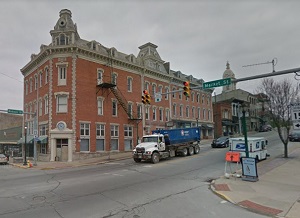
An image of Wabash
More city maps of Indiana:
- Map of South Bend
South Bend is one of the lardest cities in Indiana. It's located on the northern border of the sta... - Map of Gary
Gary, Indiana is a city located in Lake County, on the southern coast of lake Michigan, just about... - Map of Greenwood
Greenwood, Indiana is a beautiful suburban city of Indianapolis, located in Johnson County. Greenw... - Map of Mishawaka
Mishawaka, Indiana is an exceptional city situated in Penn Township of St. Joseph County. Mishawak... - Map of West Lafayette
West Lafayette, Indiana is a suburban city of Lafayette located in Tippecanoe County. The approxim... - Map of Plainfield
Plainfield, Indiana is an suburban town of Indianapolis, located in Hendricks County. Plainfield i... - Map of Goshen
Goshen, Indiana is a nice city and the county seat of Elkhar County. Founded back in 1831, today G... - Map of Granger
Granger, Indiana is a beautiful CDP situated near South Bend, in St. Joseph County. Today Granger ... - Map of Franklin
Franklin, Indiana is the county seat of Johnson County. It is home to the Franklin Courthouse and ... - Map of Clarksville
Clarksville is a town located in Clark County, Indiana. It is a suburb of Louisville, Kentucky and... - Map of Vincennes
Vincennes is a lovely city in Knox County of southwestern Indiana. The city has a population of 17... - Map of Frankfort
Frankfort is a city located in Clinton County of central Indiana. The city has 16 thousand residen... - Map of Bedford
Bedford, Indiana is a beautiful city located in Lawrence County, about 75 miles south of Indianapo... - Map of Auburn
Auburn is a charming city in DeKalb County, Indiana. It sits 20 miles north of Fort Wayne and has ... - Map of Yorktown
Yorktown, Indiana is a town located in Delaware County, about 55 miles northeast of Indianapolis. ... - Map of Columbia City
Columbia City is the county seat of Whitley County, Indiana. It is situated about 20 miles west of... - Map of Angola
Angola is a city in northeastern Indiana. It's the county seat of Steuben County, located near the...
This online map of Wabash, Indiana is provided by Bing Maps. Please add a bookmark and share the page with your friends!