The exact coordinates of Lexington Kentucky for your GPS track:
Latitude 38.048706 North, Longitude 84.499886 West.
ZIP codes for Lexington:
40502 40503 40504 40505 40506 40507 40508 40509 40510 40511 40512 40513 40514 40515 40516 40517 40522 40523 40524 40526 40533 40536 40544 40546 40550 40555 40574 40575 40576 40577 40578 40579 40580 40581 40582 40583 40588 40591 40598
Please share the link with friends and neighbors:
Share on Facebook
Share on WhatsApp
Share on Telegram
Share on Facebook
Share on WhatsApp
Share on Telegram
Check out some popular locations in Lexington:
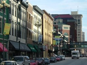
An image of Lexington
More city maps of Kentucky:
- Map of Covington
Covington, incorporated in 1815, is a city on the northern edge of Kentucky. It stands upon Ohio r... - Map of Nicholasville
Nicholasville, Kentucky is the county seat of Jessamine County. The total population of Nicholasv... - Map of Henderson
Henderson, Kentucky is a beautiful city and the county seat of Henderson County. It is located on ... - Map of Madisonville
Madisonville, Kentucky is the county seat of Hopkins County. The total population of Madisonville ... - Map of Shelbyville
Shelbyville, Kentucky is a beautiful city and the county seat of Shelby County. Shelbyville is hom... - Map of Berea
Berea, Kentucky is a charming city in Madison County. It stands about 40 miles south of Lexington.... - Map of Fort Campbell North
Fort Campbell North is a CDP located in Christian County, Kentucky. It sits near the Tennessee-Ken... - Map of Paris
Paris, Kentucky is an adorable city situated in Bourbon County. It sits 18 miles northeast of Lexi... - Map of Elsmere
Elsmere, Kentucky is a charming city found in Kenton County. It is part of the Cincinnati metropol... - Map of Fort Mitchell
Fort Mitchell, Kentucky is a beautiful city in Kenton County. It's a part of the Cincinnati-Middle... - Map of London
London, Kentucky is a city in Laurel County. It's located in the Cumberland Plateau of Kentucky, h... - Map of Flatwoods
Flatwoods, Kentucky is a city found in Greenup County. It's a part of the Huntington-Ashland metro... - Map of Cynthiana
Cynthiana, Kentucky is the county seat of Harrison County. The population of Cynthiana exceeds 6 ... - Map of Crestwood
Crestwood, Kentucky is a city in Oldham County. It sits northeast of Louisville. Today Crestwood i... - Map of Monticello
Monticello, Kentucky is an adorable city that serves as the county seat of Wayne County. Lake Cumb... - Map of Douglass Hills
Douglass Hills, Kentucky is a lovely city in Jefferson County. It's situated to the east of Louisv...
This online map of Lexington, Kentucky is provided by Bing Maps. Please add a bookmark and share the page with your friends!