Montgomery County on the map of Mississippi 2026. Cities, roads, borders and directions in Montgomery County of Mississippi.
USA / Mississippi / Montgomery CountyMontgomery County is located in the central region of Mississippi. This cool county is named after Richard Montgomery, Revolutionary War general. The county seat of Montgomery County is Winona. Formed in 1871, today Montgomery County is home to 10 thousand residents. This map shows the borders of Montgomery County as well as neighboring counties, including major highways and natural objecsts as of 2026. Zoom in or out of the map using the plus/minus panel. Move the center of this map by dragging it. Also check out the satellite map of Montgomery County.
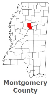
The borders of Montgomery County over the map of Mississippi
Explore some more counties of Mississippi:
- Yazoo County
- Yalobusha County
- Winston County
- Wilkinson County
- Webster County
- Wayne County
- Washington County
- Warren County
- Walthall County
- Union County
- Tunica County
- Tishomingo County
- Tippah County
- Tate County
- Tallahatchie County
- Sunflower County
- Stone County
- Smith County
- Simpson County
- Sharkey County
Full list of Mississippi maps
This online map of Montgomery County, Mississippi is provided by Bing Maps. Please add a bookmark and share the page with your friends!
© 2026 City maps and famous places