Where did the Silk Way pass? See the map!
Posted on Oct 21, 2024 / History
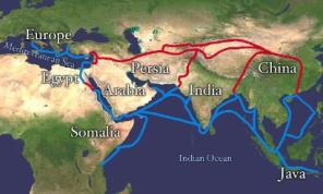
The Silk Way was an ancient commercial route from China to the Middle East and then to Europe by sea. The total length of the Silk Way exceeds 4000 miles.
It began in the famous Chinese city of Xian and went west on the southern edge of Gobi desert. Then it split into two main branches surrounding the Taklamakan desert.
The Silk Way caravans went on to the cities of Ferghana, Samarkand, Bukhara, Tehran, Baghdad and Damascus, before they met the sea, where the goods were loaded onto ships and delivered to the European customers.
Here is the full map of the Silk Way:

Please share the link with friends and neighbors:
Also! Recommended for you:
Where Does the Santa Claus Tradition Come From and Why?Where the Christmas Tree Tradition Comes From and Why?
When Jesus Was Really Born? What Historians Say?
The Top 10 Main Events of 2025 in the World
How do they celebrate Christmas in Austria?
How do they celebrate Christmas in Latvia?
© 2026 City maps and famous places