Please share the link with friends and neighbors:
Share on Facebook
Share on WhatsApp
Share on Telegram
Share on Facebook
Share on WhatsApp
Share on Telegram
San Siro Stadium is listed in:
Cool facts and FAQ about San Siro Stadium:
What’s the San Siro Stadium in Milan famous for?How can I get to San Siro Stadium from central Milan?
Can I go on a tour of San Siro Stadium when there’s no game?
What’s the seating capacity and layout of San Siro Stadium?
Are tickets hard to get for AC Milan or Inter Milan games at San Siro?
Can you bring food, drinks, or backpacks into San Siro Stadium?
Is San Siro Stadium going to be replaced or renovated soon?
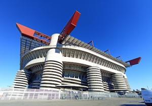
Image of San Siro Stadium:
Check out some more famous and interesting places on our planet:
- Giuseppe Dal Ben Arena
- Cortina Sliding Centre
- South Tyrol Arena
- Tofane Alpine Skiing Centre
- Cortina Curling Olympic Stadium
- Arena Santa Giulia
- Unipol Forum
- Legacy Arena
- PayPal Park
- Dick's Sporting Goods Park
- Children's Mercy Park
- Delaware Stadium
- Fargodome
- Ratliff Stadium
- Allianz Field
- Dana J Dykhouse Stadium
- Memorial Stadium at Bakersfield College
- Historic Crew Stadium
- Wailuku War Memorial Stadium
- Brooks Stadium
This online map of San Siro Stadium is provided by OpenStreetMap.
Please add a bookmark and share the page with your friends!